
UK late-autumn and early-winter weather outlook
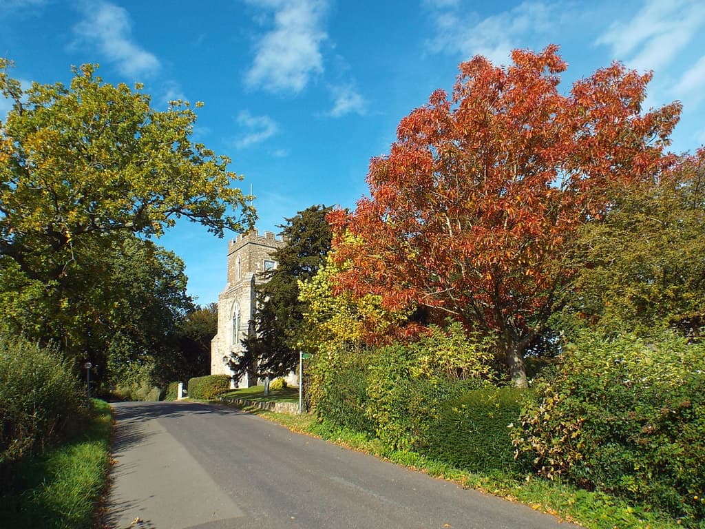
Autumn colour in Sevenoaks Weald, Kent. Photograph taken in October 2018.
Autumn colour, Sevenoaks Weald — Malc McDonald / Geograph, CC BY-SA 2.0.
Current seasonal guidance points towards an increased chance of a relatively warm, wet autumn, with windy conditions becoming more likely later in the season. An unsettled start to winter is therefore a credible possibility. However, the evidence does not justify predicting a particular December storm, prolonged freeze or snowfall in Kent. The Met Office’s September assessment supports this broad direction while emphasising considerable uncertainty over local impacts.
How seasonal forecasts work
Seasonal forecasting uses ensembles: many simulations of how the atmosphere, oceans and land could evolve. ECMWF’s seasonal system models these interacting components, while the Copernicus seasonal service combines forecasts from several centres. Their purpose is to estimate shifts in the chances of different conditions over months. This report draws on published official assessments; it is not an independent numerical comparison of every model’s September run.
El Niño’s role this winter
A major influence this year is El Niño. NOAA’s assessment issued on 10 September reports a greater than 90% chance of a very strong event during autumn and winter 2026–27. That probability describes the tropical Pacific climate event—not the probability of storms, warmth or snow in Britain.
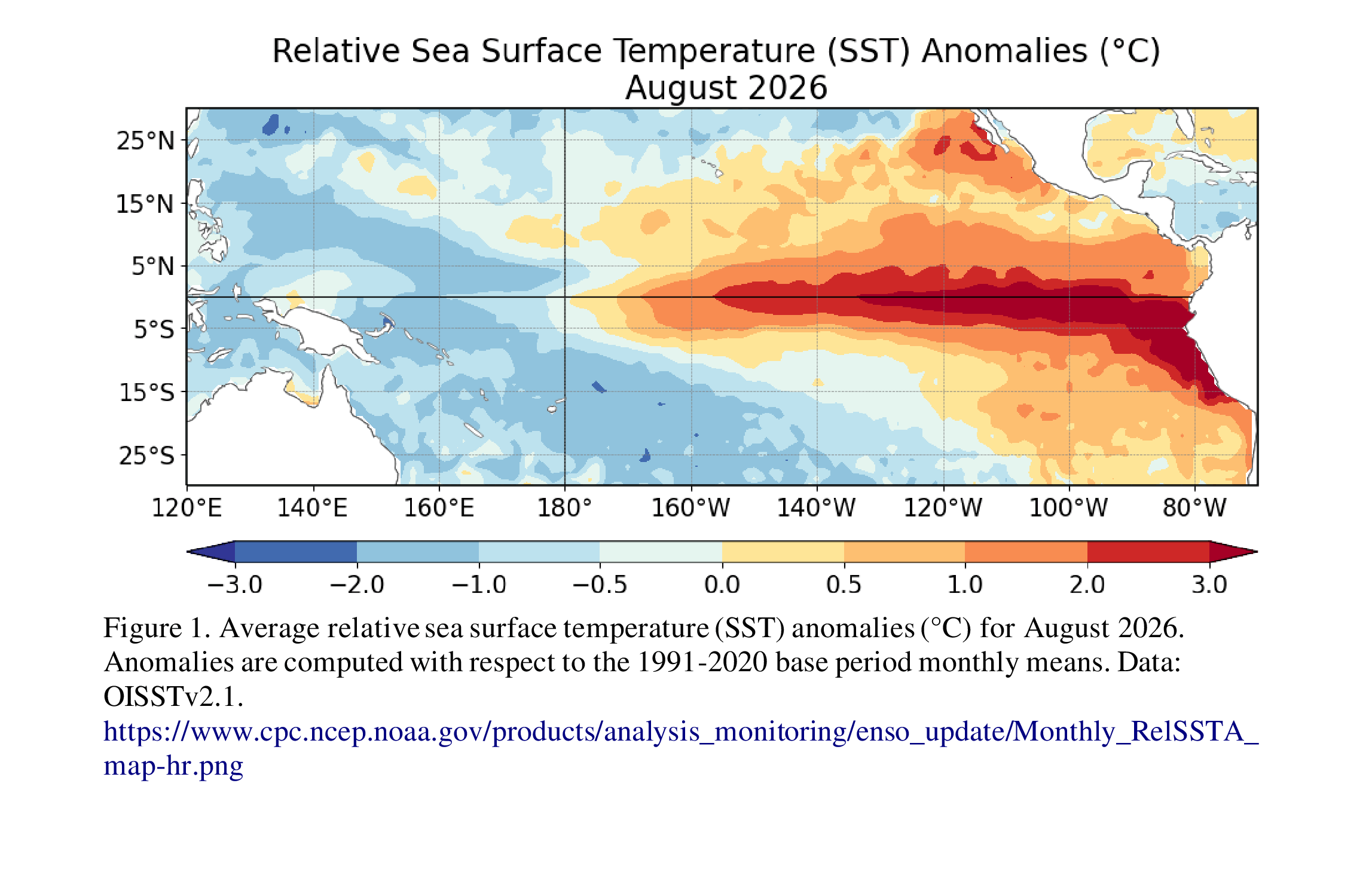
Observed Pacific sea-surface temperature departures from average. This shows the ocean conditions underlying the El Niño assessment. Click to enlarge.
Source: NOAA Climate Prediction Center. Issue date: 10 September 2026.
The UK connection is indirect. Changes in tropical rainfall and atmospheric circulation can influence weather patterns far beyond the Pacific. The Met Office associates El Niño with an increased tendency towards warmer, wetter and stormier conditions across the UK and northern Europe in late autumn and early winter. Nevertheless, other influences can reinforce or oppose that tendency, and an exceptionally strong El Niño does not automatically produce exceptionally severe UK weather.
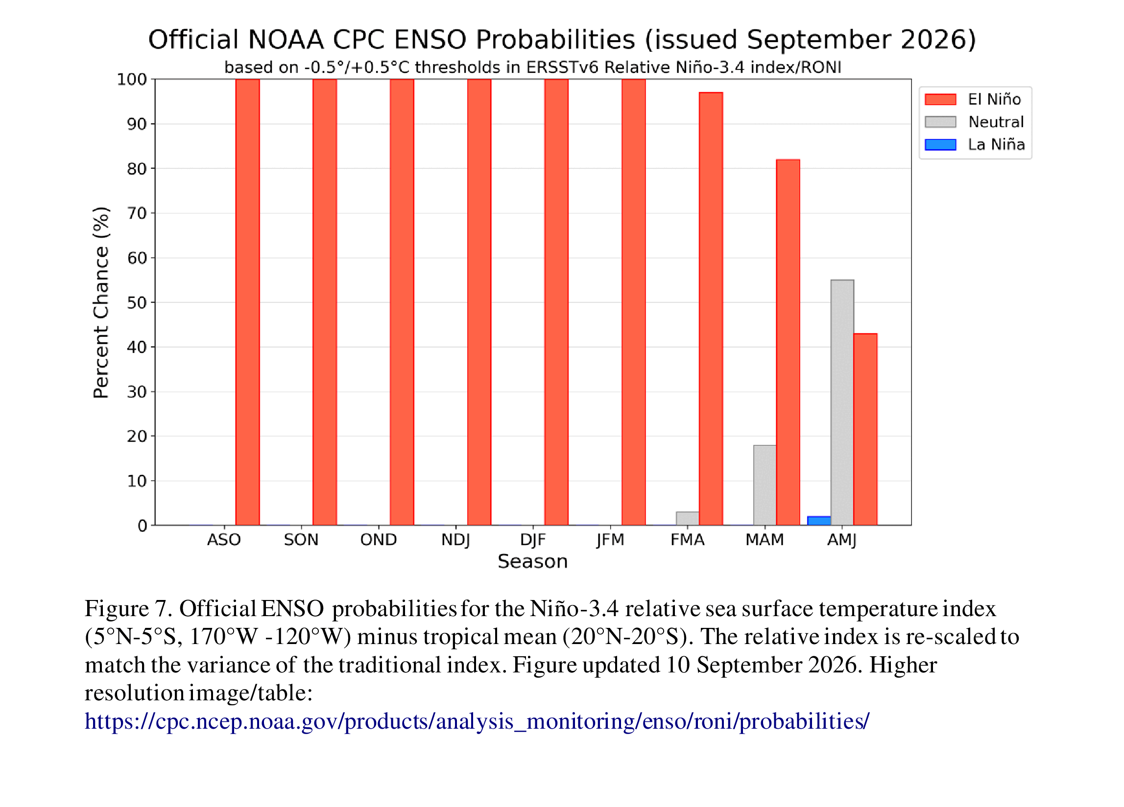
Forecast probabilities for ENSO conditions across successive three-month periods. These are Pacific climate probabilities, not UK storm or snow probabilities. Click to enlarge.
Source: NOAA Climate Prediction Center. Issue date: 10 September 2026.
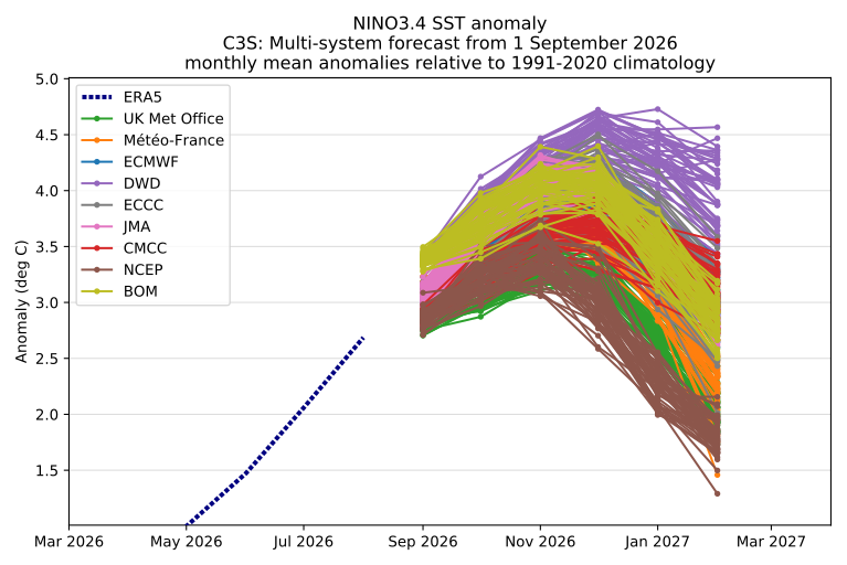
Multi-system ensemble forecast of the NINO3.4 sea-surface temperature anomaly (base time 1 September 2026). Each coloured line is one ensemble member from one forecasting centre; the dashed line is the observed value to date. Illustrates the strength of the current El Niño signal across independent models and that most expect it to ease through the winter rather than intensify further — it does not, on its own, say anything about UK conditions.
Source: Copernicus Climate Change Service (C3S) seasonal charts, implemented by ECMWF. Forecast base time: 1 September 2026. Chart saved 22 September 2026.
Late autumn: wetter and windier chances
For late autumn, the main concern is therefore a greater opportunity for wet and windy spells. The Met Office describes the chances of a warm and wet autumn as around 1.5–2 times their usual likelihood, with a windier signal emerging later. This is a change in probability, not a forecast of 1.5–2 times the normal rainfall.
European seasonal temperature and rainfall maps (to be added)
This space is reserved for Copernicus’s side-by-side October–December 2026 near-surface temperature and precipitation outlook maps for Europe. The Copernicus catalogue was checked and these products exist, but the specific map exports have not yet been downloaded or visually verified, so no image is embedded here rather than guessing at one.
To generate them: open Copernicus seasonal forecasts, choose Graphical forecast products, select the September 2026 forecast, region Europe, and period October–December 2026, then pick near-surface temperature and precipitation, keeping the same period and model combination for both. Once downloaded, replace this card with the two maps side by side, dated, with the exported chart’s own attribution, issue date, valid period and licence notice retained underneath.
Planned caption: “Seasonal temperature and rainfall outlooks for Europe. These describe conditions averaged over the selected period, rather than individual weather events.”
December and early January: more uncertainty
For December and early January, confidence is lower. The September–November outlook does not directly cover these months, so its probabilities cannot simply be carried forward. A continuation of unsettled weather is a reasonable working scenario, but a detailed month-by-month sequence would go beyond the evidence reviewed. Seasonal averages also conceal substantial variation: a relatively mild season can still contain cold spells.
Scenarios for south-east England
The following scenarios describe possible outcomes rather than separate model predictions:
| Scenario | Possible implications for south-east England | Assessment |
|---|---|---|
| Unsettled conditions continue | Repeated rainy and windy spells, with mild intervals | Consistent with the broad published outlook |
| Settled intervals interrupt the pattern | Drier periods between unsettled spells | Compatible with a wet seasonal average |
| A significant cold spell develops | Cold-weather impacts, with snow dependent on local conditions | Cannot be established from this seasonal guidance |
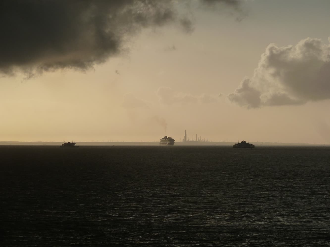
Storm clouds over the Solent, photographed in May 2016. Historical illustration, not a forecast of a particular 2026 storm.
Storm clouds over the Solent — Rob Farrow / Geograph, CC BY-SA 2.0.
These local implications are interpretations of the national outlook, not a specific forecast for Sevenoaks. Official seasonal guidance cannot reliably give the number of frost nights, snow days or individual storms at a particular location.
The stratospheric wildcard: the polar vortex
One potential source of change is the stratospheric polar vortex. A sudden stratospheric warming can alter circulation and increase the possibility of colder UK weather, but its effects are not guaranteed. The Met Office notes that individual events are reliably predictable only around one or two weeks ahead; a specific winter event cannot responsibly be announced now.
What to watch next
The next assessments should check whether successive seasonal updates maintain the same signal and whether different models agree. As winter approaches, shorter-range forecasts will become more useful for identifying cold spells, storm tracks and possible snowfall. For now, the evidence supports preparing for unsettled late-autumn weather while keeping early-winter outcomes open.