
Ro-Weather outlooks are automated, not official warnings. In the UK, follow the Met Office.
Weather guide
Atmospheric Weight & Weather Drivers
Atmospheric Weight - Force exerted by weight of air column above a point
Millibars (mb) - Standard sea-level pressure 1013.25 mb or 29.92 inches Hg
Pressure Gradients - Pressure differences drive wind and weather patterns
Atmospheric pressure is the force exerted by the weight of the entire column of air above any point on Earth's surface. At sea level, this pressure is approximately 14.7 pounds per square inch (1013.25 millibars). Pressure decreases with altitude because there is less air above. Pressure differences between regions drive wind, influence weather patterns, and determine whether storms develop or dissipate.
Sea Level: 1013.25 mb (29.92 inches Hg)
5,000 ft: ~842 mb (24.9 inches)
10,000 ft: ~696 mb (20.6 inches)
35,000 ft (jetliner): ~239 mb (7.1 inches)
Rule: Pressure drops roughly half every 18,000 feet
Warm Air: Expands, pressure decreases (low pressure areas)
Cold Air: Contracts, pressure increases (high pressure areas)
Daily Cycle: Pressure lowest in afternoon (warmest), highest at dawn
Seasonal: Pressure highs in winter, lows in summer (land masses)
Characteristics: Pressure greater than surroundings, dense air sinking
Air Movement: Winds spiral outward (clockwise in NH)
Weather: Clear skies, fair weather, dry conditions
Temperature: Generally cooler, stable conditions
Duration: Can persist for days or weeks
Symbol: H on weather maps
Characteristics: Pressure lower than surroundings, warm air rising
Air Movement: Winds spiral inward (counterclockwise in NH)
Weather: Clouds, precipitation, often stormy
Temperature: Generally warmer, unstable conditions
Duration: Transient, typically 3-7 days
Symbol: L on weather maps
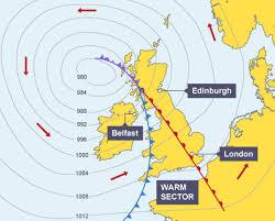
Isobars are lines connecting points of equal pressure on weather maps. The spacing and orientation of isobars reveal wind strength and direction.
Pressure Tendency: Whether pressure is rising or falling indicates approaching weather changes. Falling pressure suggests incoming storms; rising pressure suggests improving conditions.
Fundamental Law: Air flows from high to low pressure
Pressure Gradient Force: Drives air in direction of steepest pressure drop
Coriolis Effect: Deflects moving air perpendicular to flow (creates angle)
Geostrophic Balance: Wind eventually flows along isobars (parallel to pressure lines)
Direct Relationship: Tighter isobars = stronger winds
Gradient Strength: Wind speed proportional to pressure gradient
Jet Streams: Form where pressure gradients steepest (temperature contrasts)
Extreme Winds: Hurricanes have extreme pressure gradients and extreme winds
Pressure Range: 880-960 mb (extremely low)
Gradient: Extraordinarily steep around eye
Winds: 74+ mph sustained, 100-150+ mph in eyewall
Size: Can be 300-600 miles across
Duration: Days to weeks with consistent structure
Pressure Drop: Extremely low in vortex core (less than 850 mb)
Gradient: Most extreme pressure gradient on Earth
Winds: 100-200+ mph rotational, circular motion
Damage: Winds combined with low pressure cause explosive damage
Duration: Minutes to seconds of intense activity
Altimeter Setting: Pressure adjusted to what would occur at sea level, allowing pilots to determine altitude. When pressure is low (low altimeter setting), altimeters read higher than actual altitude - a critical safety issue.
Each 0.1 inch of altimeter difference = 1,000 feet of altitude error. Flying into low pressure without adjusting altimeter can cause collision with terrain.
 Ro-Weather