
Ro-Weather outlooks are automated, not official warnings. In the UK, follow the Met Office.
Weather guide
Tropical Cyclones of Devastating Power
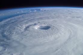
Organized rotating storm with eye, eyewall, and rainbands
Requires warm water above 80°F and low wind shear
Saffir-Simpson: Category 1-5 with sustained winds 74+ mph
A hurricane is a tropical cyclone with maximum sustained winds of 74 mph or higher. Known as typhoons in the Western Pacific and cyclones in the Indian Ocean, these massive rotating storm systems can span hundreds of miles and persist for weeks. They form over warm tropical oceans and weaken rapidly over land or cool water.
Sea surface temperature above 80°F (26.5°C). Warmer water provides more energy for storm intensification.
Minimal changes in wind speed/direction with altitude. High shear tears storms apart and disrupts rotation.
Moist air at surface with drier air aloft. Creates instability for thunderstorm development and rotation.
Damage: Damage to siding/shingles, some trees snapped, mobile homes damaged, power outages
Damage: Some roofs torn, many trees snapped/uprooted, mobile homes destroyed, widespread power loss
Damage: Many buildings destroyed, trees debarked, near-total power loss, human suffering increasing
Damage: Most homes destroyed, catastrophic damage, long-term power outages, uninhabitable for weeks
Damage: Catastrophic damage, many wood frame homes destroyed, area uninhabitable for weeks/months
Calm center with light winds and sometimes clear skies. Surrounded by eyewall with strongest winds and heaviest rain.
Intense thunderstorms surrounding eye with maximum winds and heaviest rainfall rates.
Spiral bands of thunderstorms extending outward from hurricane center. Decrease in intensity moving outward.
Outflow aloft allows air to exit hurricane top, sustaining low pressure and circulation.
Sustained winds 74-157+ mph cause catastrophic damage to structures, vegetation, and infrastructure.
10-40+ inches of rain in 1-2 days causes devastating flooding and mudslides, especially inland.
Ocean water pushed up to 20+ feet above normal by wind pressure. Most destructive hurricane hazard at coast.
Embedded in rainbands, particularly in northeastern eyewall. Often weaker than supercell tornadoes but dangerous.
Warmest ocean temperatures, peak storm formation
Most intense storms, highest category hurricanes
3.5 hurricanes, 1.5 major hurricanes
 Ro-Weather