
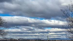
Stratocumulus Clouds
Low Lumpy Layer Clouds ☁️
Altitude
2,000 - 6,500 feet
Low cloud genus
Appearance
Lumpy, rounded patches with gaps of blue sky
Rarely a solid, unbroken sheet
Global Coverage
The most common cloud type on Earth
Especially widespread over the oceans
What Are Stratocumulus Clouds?
Stratocumulus clouds are low, lumpy patches or rolls that sit somewhere between the flat, featureless sheet of stratus and the tall, isolated puffs of cumulus. They're the cloud you get on a day that's neither properly sunny nor properly grey — broad grey-and-white masses with genuine gaps of blue sky showing through, rather than the complete overcast of stratus. Globally they're the single most frequently observed cloud type, and they're especially persistent as huge marine decks over cool ocean currents, where they play a significant role in reflecting sunlight back to space and cooling the water beneath them.
Formation & Characteristics
How It Forms
- 1. Capped Convection: Rising thermals hit a temperature inversion and can't punch through, so they spread sideways instead of building upward like cumulus.
- 2. Breaking Stratus: An existing stratus sheet can break up into stratocumulus patches as light convection returns, often in the morning.
- 3. Marine Subsidence: Over cool ocean water, sinking air traps moisture in a shallow layer, producing vast, persistent stratocumulus decks.
- 4. Wave Action: Airflow disturbed by hills or wind shear can roll the layer into the parallel bands typical of stratocumulus undulatus.
Key Characteristics
- ✓ Elements: Larger than altocumulus, over 5° of arc
- ✓ Shading: Grey on thicker parts, white where thinner
- ✓ Gaps: Blue sky often visible between patches
- ✓ Arrangement: Rounded masses, rolls, or a broken sheet
- ✓ Base: Relatively flat and well-defined
- ✓ Composition: Water droplets, occasionally supercooled
Common Forms
Stratiformis
A wide, mostly continuous sheet made of joined-up patches — the most common everyday form.
- • Covers large areas
- • Patchy gaps still visible
- • Typical grey overcast look
Lenticularis
Smooth, lens- or almond-shaped clouds, usually formed by air flowing over hills or mountains.
- • Distinctive UFO-like shape
- • Stays roughly stationary in strong wind
- • Common downwind of high ground
Castellanus
Small turreted tops rising from a common base, a sign that the layer is becoming unstable.
- • Turret-like bumps on top
- • Suggests building instability
- • Can be a precursor to storm development
What Stratocumulus Means
Typical Conditions
- • Fair to partly cloudy, generally settled
- • Little or no precipitation
- • Common at dawn and dusk as convection weakens
- • Frequently seen over coasts and cool seas
Watch For
- • Thicker decks can produce light drizzle or snow grains
- • Castellanus turrets can signal developing instability
- • A widening, thickening sheet can precede a frontal system
Why Marine Stratocumulus Decks Matter
Some of the largest, most persistent stratocumulus sheets on Earth sit over cool ocean currents off coastlines like California and Namibia. Because they're bright and reflective, they bounce a significant amount of incoming sunlight back to space before it can warm the ocean — a genuine factor in the planet's overall energy balance, and one reason climate scientists pay close attention to how these decks might respond as sea temperatures change.