
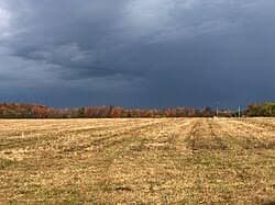
Nimbostratus Clouds
Dark Continuous Rain Clouds 🌧️
Altitude
Base 2,000 - 10,000 feet, extends much higher
Officially a mid-level genus
Appearance
Very dark, thick, featureless
Blots out the sun completely
Precipitation
Continuous rain or snow, no thunder
Steady, not convective
What Are Nimbostratus Clouds?
Nimbostratus clouds are thick, dark, featureless sheets that produce continuous, steady precipitation over a wide area — the cloud responsible for the kind of all-day rain that soaks everything rather than the short, heavy burst of a passing shower. They completely block direct sunlight, leaving a flat, gloomy grey light with no visible cloud structure at all. Unlike cumulonimbus, nimbostratus forms through broad, gentle lifting rather than strong convection, so it produces rain or snow without thunder or lightning. It's the mature end-point of the classic warm-front sequence — cirrus thins into cirrostratus, thickens into altostratus, and finally into nimbostratus once precipitation reaches the ground.
Formation & Characteristics
How It Forms
- 1. Thickening Altostratus: As a warm or occluded front nears, the altostratus layer above it thickens and lowers.
- 2. Deep Ascent: Warm, moist air is lifted steadily over the frontal surface across a huge horizontal area.
- 3. Saturation Through Depth: The cloud grows so thick — often several kilometres — that it blocks essentially all sunlight.
- 4. Precipitation Reaches the Ground: Once the layer is dense enough, droplets and ice crystals grow large enough to fall as steady rain or snow rather than evaporating (virga) on the way down.
Key Characteristics
- ✓ Colour: Very dark, near-uniform grey
- ✓ Structure: No visible texture or shape
- ✓ Thickness: Can extend several kilometres vertically
- ✓ Sun/moon: Completely obscured
- ✓ Duration: Persists for many hours, sometimes over a day
- ✓ Sound: No thunder — this cloud isn't convective
The Odd One Out in Cloud Classification
Of the ten official cloud genera, nimbostratus is the one exception to the tidy low/mid/high altitude bands. Its base commonly sits low enough to touch hill fog, yet the international cloud atlas still classifies it as a middle-level genus — because its bulk routinely spans from near the surface up through several kilometres of the atmosphere, making a single altitude band meaningless for it. That sheer vertical thickness is exactly why it can absorb so much sunlight and why the rain it produces is so persistent: there's a huge reservoir of moisture-laden cloud above to keep feeding it.
Ragged Cloud Underneath: Pannus
Beneath a nimbostratus base you'll often see ragged, fast-moving scraps of cloud drifting well below the main layer — an accessory cloud feature called pannus (sometimes casually called “scud”). It forms when falling rain evaporates into the humid air near the ground and immediately re-condenses as fresh moisture rises to meet the cold falling rain. It looks dramatic and can occasionally be mistaken for something more threatening, but on its own, under nimbostratus, it's a normal and harmless companion to ordinary steady rain — not a sign of a developing storm.
What to Expect
Typical
- ✓ Steady, moderate rain or snow — not heavy bursts
- ✓ Can last from several hours to over a day
- ✓ Poor light levels throughout, even at midday
- ✓ Cool, damp conditions with little wind change
Not Typical
- • Thunder or lightning — this isn't a convective cloud
- • Sudden, brief, heavy downpours
- • Rapid clearing — it moves and dissipates slowly