
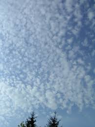
Cirrocumulus Clouds
High Puffy Ice Clouds ☁️
Altitude
20,000 - 40,000 feet (6 - 12 km)
High cloud genus
Cloudlet Size
Under 1° of arc — a finger's width at arm's length
Smaller than altocumulus
Shading
None — too thin to cast self-shadow
Distinguishes it from altocumulus
What Are Cirrocumulus Clouds?
Cirrocumulus clouds are small, white cloudlets that form very high up, generally 20,000 to 40,000 feet, in rippled rows or grain-like patches. Despite the puffy, cumulus-style look, they aren't made of water droplets the way low cumulus clouds are — at this altitude the air is so cold that the cloud is almost entirely tiny ice crystals, with any liquid droplets present existing only briefly as supercooled water before freezing. The individual cloudlets are small enough that each one covers less than a degree of sky, roughly the width of a finger held at arm's length, and the whole sheet is thin enough that it never develops the shaded, three-dimensional look of altocumulus below it. When the pattern lines up in tight rows across a wide stretch of sky it produces the classic “mackerel sky” — named for its resemblance to fish scales.
Formation & Characteristics
How It Forms
- 1. High-Altitude Moisture: A thin, moist layer sits at cirrus-level altitude where temperatures are typically -20°C to -60°C.
- 2. Shallow Convection: Weak turbulence or gentle convective cells break the layer into small, evenly-spaced cloudlets rather than one solid sheet.
- 3. Rapid Glaciation: Any liquid droplets that briefly form freeze almost immediately at these temperatures, leaving a cloud of fine ice crystals.
- 4. Wave Patterns: Atmospheric gravity waves can arrange the cloudlets into the regular ripples typical of a mackerel sky.
Key Characteristics
- ✓ Colour: Bright white, no grey shading
- ✓ Shape: Small grains, ripples or rounded tufts
- ✓ Pattern: Often arranged in regular rows
- ✓ Composition: Almost entirely ice crystals
- ✓ Duration: Usually short-lived, dissipates or evolves quickly
- ✓ Coverage: Patchy, rarely covers the whole sky
The “Mackerel Sky”
When cirrocumulus (or altocumulus) forms in dense, regular rows, sailors and forecasters have long called it a mackerel sky, for its likeness to the scale pattern on a mackerel's back. The old British weather rhyme sums up what it does and doesn't mean:
“Mackerel sky, mackerel sky, never long wet, never long dry.”
What It Reflects
- • High-altitude turbulence and shifting winds aloft
- • Often appears as one weather regime is giving way to another
- • A visual cue, not a reliable short-range forecast on its own
What It Doesn't Mean
- • It is not a direct sign of imminent rain
- • It rarely persists for long — it usually clears or spreads within hours
- • It should never replace a real forecast or official warning
Cirrocumulus vs. Altocumulus
Cirrocumulus
- • Higher: 20,000–40,000 feet
- • Cloudlets under 1° of arc
- • Pure white, no visible shading
- • Almost entirely ice crystals
Altocumulus
- • Lower: 6,500–20,000 feet
- • Cloudlets 1°–5° of arc, visibly larger
- • Shows grey shading on the underside
- • Mostly water droplets, some supercooled