
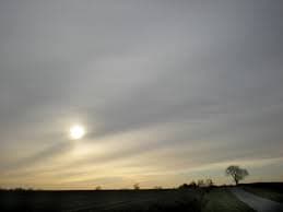
Altostratus Clouds
Thin Mid-Level Gray Clouds ☁️
Altitude
6,500 - 20,000 feet (2 - 6 km)
Mid-level cloud genus
Sun Visibility
Faint, like ground glass — no halo
Too dense for a clean disc
Precipitation
None at the surface, usually
Signals rain within 12-24h
What Are Altostratus Clouds?
Altostratus clouds are featureless gray or blue-gray sheets that spread across large stretches of the mid-level sky, roughly 6,500 to 20,000 feet up. Look up through one and the sun or moon shows only as a dim, blurred patch — as if you were looking at it through a pane of ground (frosted) glass. That faint, hazy disc is the single clearest way to identify the cloud: it is dense enough to blot out sharp shadows and any halo, but still thin enough to let some light through. Altostratus almost never reaches all the way down to affect ground-level visibility the way stratus or fog does, and it very rarely drops rain that survives the fall to the surface — its real significance is as a forecasting signal, not as weather in its own right.
Formation & Characteristics
How It Forms
- 1. Warm Front Approaches: A mass of warm, moist air rides up and over the retreating cold air ahead of a warm front.
- 2. Gradual Ascent: Unlike the sharp, localized lift that builds cumulus clouds, this is broad, gentle lifting spread over hundreds of miles.
- 3. Mixed-Phase Layer: At this altitude the air straddles the freezing level, so the cloud is made of a mix of supercooled water droplets and ice crystals.
- 4. Thickening: As the front gets closer, the layer thickens and lowers — the next stage in the sequence is nimbostratus and steady rain.
Key Characteristics
- ✓ Colour: Grey or blue-grey, darker than cirrostratus
- ✓ Sun/moon: Visible only as a faint, diffuse smudge
- ✓ Halo: None — it's the giveaway that separates it from cirrostratus
- ✓ Coverage: Broad, often covers the whole sky
- ✓ Structure: Largely featureless, sometimes faintly fibrous or striated
- ✓ Composition: Water droplets, supercooled droplets and ice crystals together
Altostratus Varieties
Altostratus Translucidus
The thinner variety. Sun or moon still shows through as a soft, watery glow, though never sharp enough to cast a defined shadow.
- • Sun/moon position is easy to judge
- • Earlier stage of an approaching front
- • No precipitation reaching the ground
Altostratus Opacus
Thick enough to hide the sun or moon completely. Marks the layer thickening as a front draws nearer, often just hours from rain.
- • No sun/moon visible at all
- • Sky looks uniformly dull and grey
- • Often thickens into nimbostratus next
Telling It Apart From Similar Clouds
vs. Cirrostratus
- • Cirrostratus is higher (20,000ft+) and pure ice
- • Cirrostratus produces a sharp 22° halo; altostratus never does
- • Cirrostratus lets the sun show as a clean disc, not a smudge
vs. Stratus / Nimbostratus
- • Stratus sits much lower, often below hilltop level
- • Nimbostratus is thicker still and actively raining
- • Altostratus is the “not yet raining” stage in between
Key Facts About Altostratus Clouds
Physical Properties
- • Thickness: often several thousand feet
- • Mixed-phase: water droplets and ice crystals
- • Can produce virga (rain that evaporates before landing)
- • Colour deepens as the layer thickens
Weather Significance
- • Classic warm-front indicator
- • Usually precedes rain by 12-24 hours
- • Thickening/lowering means the front is getting closer
- • Follows cirrus and cirrostratus in the sequence